From
the Summit of Mt. Whitney,
with the world at your feet
(a
360-degree panorama)
I had the
pleasure of climbing Mt. Whitney, elev. 4421 m (14,505
ft), back in August '89 with a couple
of buddies from the Phoenix traffic engineering firm we were working
for at the
time. It's not only the highest peak in California, but also the
tallest peak in the contiguous
U.S. 48 states.
Recently another friend sent me email that he was planning to
summit Mt. Whitney this year, and it reminded me of
the above 22-year-old, 360-degree panorama shot that one my
climbing buddies
spliced together from taking 16 sequential snapshots from the summit
(we were not very high-tech in '89.....well, to be fair, digital
cameras were not widely available at the time).

Well.......THAT motivated me to go dig it out, dust it off, &
digitize it,
and now above you can see the finished product. I apologize
for
the quality, as I'm not very proficient w/ Photoshop,
plus....bless its heart....the pic's been scotch-taped and push-tacked
onto an uncountable # of walls in an uncountable # of abodes over the
past 2 decades.
But nonetheless it's pretty remarkable, though, when you consider the
awesome view of Death Valley (the lowest point in North America @ 282
ft. (86 m) below sea level) only
76 miles to the east and Sequoia National Park (home to the famous
giant redwood trees) to the
west (technically, the western slope of Whitney is inside
Sequoia NP).
And
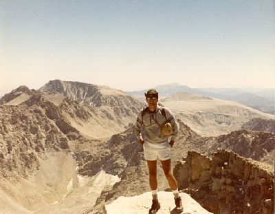
here's another pic of me atop Mt. Whitney:

Enjoy !!
Oh
yeah, my all-time favorite 360-degree panorama was taken from the
summit of Mt. Everest, our planet's highest peak, by
Australian
photographer Roderick Mackenzie, and posted in a phenomenal fashion by
a friend in Pennsylvania. Wow, check it out:
http://pajamas2robe.home.comcast.net/%7Epajamas2robe/mountains.html
(best
viewed with Internet Explorer!)
[Oops, that
link went south! Sorry 'bout that.]


