Mt. Ontake-san (御嶽山)
elev. 3067m
Japan's 14th
Highest Mountain
The 2021 climbing season for Mt. Ontake opened on June 7.
Note:
Mt. Ontake-san is a very dangerous active volcano and erupted without
warning on Sat. Sept. 27, 2014, killing at least 56 hikers. More
details on the eruption, including updates, are here.
|
Climbing Mt. Ontake-san (御嶽山), elevation 3067m, the 14th highest
mountain
in Japan, was without question the most religious & spiritual
hike I've ever taken
in Japan. The climbing trail has little shrines, temples, and statues
of religious deities pretty much along the entire course.
In fact, I even had the good fortune of meeting a couple of Buddhist
mountain
priests (yamabushi, 山伏) on the trail, a pic of which you can see in my
Flickr album below. Mt. Ontake-san (御嶽山) is a famous peak for these
priests
as part of their religious and physical training.
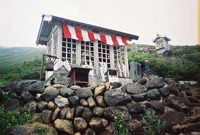
Shrine along the Mt. Ontake-san climbing trail
Easy Hike !
And for being a "three-thousander" (peak over 3000m), it was one of
the
easiest of Japan's 25 highest mountains that I've ever climbed. On that
day, I left
Shinjuku Station in Tokyo at 7 am, started hiking at 12:30 pm, reached
the summit of Mt. Ontake-san (御嶽山) @ 3:20 pm, and finished
hiking at
7 pm at the Asahi-so minshuku in Nigorigo
Onsen (濁河温泉) where I spent
the
night. That's right……it was a 6 1/2
hour day hike.
One reason for this was that the summit of Mt. Ontake-san (御嶽山),
elev. 3067m, which is also Japan’s 2nd
highest volcano, is less than a 900m elevation gain from the
Ta-no-hara (田の原) trailhead (elev. 2190m), and from there, an
approximate
1300m elevation drop down to Nigorigo
Onsen (濁河温泉) @ 1768m.
To my best recollection, this trailhead is one of the highest elevation
trailheads among the 25 highest mountains in Japan.
The only 2 higher ones that immediately come to mind are the Mt. Fuji
Fifth Station (富士山五合目 ) trailhead (elev. 2305m, Kawaguchiko Trail) and Mt.
Tateyama/Mt. Tsurugi-dake trailhead in Murodo (elev.
2433m).
The 5 Crater Lakes (5つの火口湖) of
Mt. Ontake-san (御嶽山)
The weather wasn't all that great that day. In fact, it was cloudy and
foggy all day, and even rained a bit in the late afternoon. But I did
manage to see some very pretty scenery on this hike. I believe my
favorite spot was San-no-ike (三ノ池, Lake #3), one of 5 greenish-blue
crater
lakes in the
area.
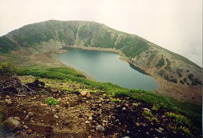
San-no-ike (三ノ池), one of Mt. Ontake-san's 5 crater lakes
According to Wikipedia, Ni-no-ike (二ノ池, Lake #2), elev. 2905m, one of
the other
5 crater lakes & photos of which are in my Flickr album below,
is the
highest mountain lake in Japan. And I had a nice break at the
Go-no-ike-goya (五ノ池小屋, Lake #5 mountain hut) where I enjoyed a very
cool & refreshing Coca-Cola.
Nigorigo
Onsen (濁河温泉)
One of the
most delightful parts of this hike was that at the end of the course,
there was a hot spring waiting for me. I stayed in a very delightful
place called Asahi-so, a minshuku in Nigorigo
Onsen (濁河温泉) right
near the end
of the hiking course that was adorned with colorful cosmos
flowers (コスモス) (see pic in my photo album below) and had a very nice rotemburo (露天風呂, open air bath) to
relax in (too bad I was alone). 
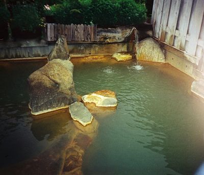
Rotemburo @ Asahi-so minshuku
It seems the prices have gone up in the 10 years since I stayed there,
but the overnight stay, including dinner and breakfast, only set me
back ¥6150, cheaper than what it costs in most mountain huts.
Perhaps the lucky gaijin got a discount. 
Nigorigo Onsen (濁河温泉) is a very
beautifully forested area and a natural
habitat to a number of birds, including robins, warblers, and
flycatchers. It prides itself on very little light pollution, so is a
popular area for stargazing and a number of the lodges in the area even
have
telescopes on their rooftops.
But by far my favorite spot in Nigorigo Onsen (濁
河温泉) was the nearby
spectacular Sennin Falls (仙人滝) on the upper Nigorigo River (濁河川上流),
which is
lit up
at nighttime. As I recall, this was the first time for me to ever
experience such a nighttime light-up of a waterfall in Japan.
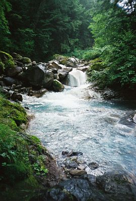
Upper Nigorigo River (濁河川上流)
My Mt. Ontake-san (御嶽山) Pics
My Mt.
Ontake-san (御嶽山) photos are hosted at
Flickr, where I hope
they give you a sense of the
exciting experience
of what it was like to actually be there.
Click here to view all of my Mt. Ontake-san
(御嶽山) pics, taken
Aug. 9-10, 2001. Enjoy!
My Google Map of Mt. Ontake-san (御嶽山)
In Oct. 2009 I created the customized map below, as I thought it'd be
cool to see all of Japan's 25 highest mountains at a glance.
(zoom out to see all 25 highest
mountains)
View 25 Highest
Mountains in Japan in a larger map
Note: The highest of the Ontake-san peaks is called Ken-ga-mine (剣ヶ峰).
Route Description, Maps & Elevation
Profiles
of Mt.
Ontake-san (御嶽山)
Interestingly, the hiking trail up from Ta-no-hara (田の原) has numbered
stations, similar to Mt. Fuji: 7th Station (nanagome, 七合目), 8th Station
(hachigome, 八合目), etc. (see route
map below). From the Ta-no-hara (田の原) trailhead to the Mt. Ontake (御嶽山)
summit (also called Ken-ga-mine, 剣ヶ峰), it took me a little
less
than 3 hours. About 20 minutes from the top, you'll pass the
Otaki-chojo-goya (王滝頂上小屋) mountain hut, a pic of which is in my photo
album.
To be honest, the summit of Mt. Ontake-san (御嶽山) was a bit too
commercialized for me, reminding me a bit of the entire "city" one
finds at the
top of Mt. Fuji.
In addition to the two mountain huts, Ontake
Chojo-sanso (御嶽頂上山荘) & Ken-ga-mine Asahi-kan (剣ヶ峰旭館), which
together sleep over 200, along with a souvenir shop & what
seemed like an uncountable
number of shrines and temples at the summit, it was difficult
to catch that
"back-to-nature" feeling. 
Note: The route above shows the first half of my hiking course
from Ta-no-hara (田の原) up to the summit of Mt. Ontake-san (御嶽山).
Note: The route above shows the second half of my hiking
course
from the summit of Mt. Ontake-san (御嶽山) down to Nigorigo
Onsen (濁河温泉).
Access
Despite its remote & isolated location to the west of
the Central Japan Alps (see Google map
above), Mt. Ontake-san (御嶽山) is still easily accessible from
Tokyo, and there are
a number of ways to approach the peak, including from
Nigorigo
Onsen (濁河温泉) or via the Ontake Ropeway (御岳ロープウェイ), which
operates from
July thru early November.
Alternatively, I chose to take the bus from Kiso-Fukushima Station
(木曽福島駅) to the Ta-no-hara (田の原) trailhead, which takes about
an hour and 15 minutes and will set you
back ¥1500.
There are 3 buses a day (in each direction) every day from
mid-July thru the end of August, and weekend/holiday service only from
the beginning of Sept. thru mid-October.
During the summer & fall seasons, the
bus timetables (in Japanese) are posted on the Otaki Village website. [Google Translate is a fairly
accurate resource for translating Japanese webpages
into English (and vice
versa).]
From Shinjuku Station, you can take JR East's Azusa or Super
Azusa limited
express trains on the Chuo Line (that depart about every half-hour),
which will
take you to Shiojiri Station (塩尻駅) in
2 1/2
to 3 hours (timetable). From there, you can
transfer to the Chuo
Main Line (run by
JR Central) for Kiso-Fukushima Station (木曽福島駅)
on limited express
trains which'll take about an additional 30 minutes. In Aug. 2001,
these
2 trains dented my pocketbook by ¥7660.
For more train scheduling/fare info, you can call JR East
in English @ 050-2016-1603 (+81-50-2016-1603 from overseas). They are
open 10:00 to 18:00 everyday, except during the year-end/new
year holidays.
Please stop by again soon
In summary, climbing Mt.
Ontake (御嶽山) was a short,
yet scenic & enjoyable hiking trip, especially with
that hot spring waiting for me at the end of the day.
I thoroughly enjoyed the 5 crater lakes (5つの火口湖), colored in various
shades of
blue & green. I was also touched by the very quaint &
scenic hot spring town of Nigorigo Onsen (濁河温泉), which I wouldn't mind
returning back to again someday.
Please
stop by again soon, as
in the future I intend to update this page on
climbing Mt.
Ontake-san (御嶽山) with more
details as they become available. In the meantime, you may wish to
check out the record of my Mt.
Ontake (御嶽山) schedule and expenses.
I also hope you have a few extra minutes to check out my
webpages
on the other highest mountains in Japan, as well as the rest
of my
website.
Thanks so much for visiting, and if you have any questions for me,
by all means please give me a shout
by clicking on the "Contact Me" link. I would also love to
hear
your personal story if you've already climbed Mt.
Ontake-san (御嶽山). You can share your story here.
Best wishes !!
Additional links:
Mt. Ontake-san summit 6-day weather forecast
Mt.
Ontake-san topo map (from the Geospatial
Information Authority of Japan)
Mt. Ontake-san route map (2023 1:50,000 hiking map part
of the
Yama-to-kogen Chizu series published by Shobunsha)
Back
to The Highest Mountains in Japan
|
|


